


Scales
Scales are used to show the distance between different points on a map. Scales are usually shown in kilometers and miles. Let's take a look at a simple way to read the distance between two points on the map below.
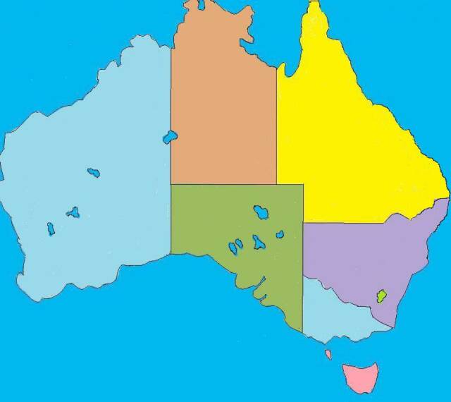
Australia
Northern
Territory
Queensland
New South
Wales
Tasmania
King I
Western
Australia
South
Australia
Victoria
Adelaide
Melbourne
Sydney
Darwin
Hobart
A.C.T
Southern Ocean
Coral Sea
Canberra
Notice that the scale above shows both kilometers and miles. Now suppose you want to find the distance between Melbourne and Sydney. To find the distance in kilometers, begin by lining up a piece of paper beneath the scale shown to the left. Then, mark the distance of kilometers along the edge of the paper. Make sure that the markings are the same distance apart as the actual scale. Next, line up the paper beginning with zero at Melbourne ending at Sydney. You will see that Melbourne is about 900 kilometers from Sydney.
Use the same procedure to find the distance in miles. This time, line up the paper beneath the scale shown. Then, mark the distance of miles along the edge of the paper. Next, line up the paper beginning with zero at Melbourne ending at Sydney. Sydney lies a bit more than midpoint between 400 and 600 miles. So, Melbourne is about 550 miles from Sydney.
Just For Fun
1. About how many kilometers is Adelaide from Melbourne?
2. About how many miles is Canberra from Sydney?
3. About how many kilometers is Canberra from Melbourne?
Answer: Click here
kilometers
miles
0 200 400 600 800 1000
0 200 400 600
Brisbane